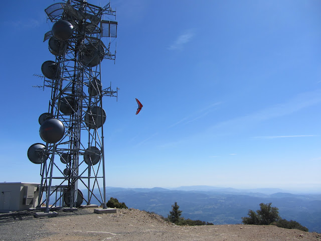
Mount St. Helena is the highest point in Sonoma County, CA. From Napa, follow past Calistoga on highway 29 up a section of road that has many curves, pay attention for a sign about 8 miles up the road and you will see a small parking lot, no fees. This is a relatively easy out and back hike. No points to fill up on water, so pack it in. The first section is a covered trail the includes switch backs. For the majority of the trip, you will be on a gravel road (a little disappointing) only traveled on by hang gliders (two vans passed us on the road with their equipment on top) and maintenance crew. Since it is relatively easy, on nice days, expect a lot of people. Since there is little cover for most of the hike, better to do on cooler days in the Fall or Spring. The views make the hike worth it. There are some nice rock climbing walls along the way as well. Once you get to the top, there are nice places to sit with almost a 360 view of the entire region. It is also fun watching the hang gliders use the up draft to fly around above you. You share the top of the mountain with a huge antenna tower (not very pretty). This is a longer hike and gives you great perspective of the surrounding geography. Probably not a hike I would do again. March, 2013. 10 miles.
My blog is intended to be an informative guide for hiking and backpacking. While books and official sites are helpful, I am always left with a sense of uncertainty about the adventure. I figured it would be helpful to have a little more qualitative data and some pictures to help inform your choices. I also hope to share my adventures with friends and family who wonder what I do with my time. Suggestions on places to hike or what to include in my blog would be much appreciated! Enjoy!
Monday, March 25, 2013
Mount Saint Helena, CA- Robert Louis Stevenson State Park
Mount St. Helena is the highest point in Sonoma County, CA. From Napa, follow past Calistoga on highway 29 up a section of road that has many curves, pay attention for a sign about 8 miles up the road and you will see a small parking lot, no fees. This is a relatively easy out and back hike. No points to fill up on water, so pack it in. The first section is a covered trail the includes switch backs. For the majority of the trip, you will be on a gravel road (a little disappointing) only traveled on by hang gliders (two vans passed us on the road with their equipment on top) and maintenance crew. Since it is relatively easy, on nice days, expect a lot of people. Since there is little cover for most of the hike, better to do on cooler days in the Fall or Spring. The views make the hike worth it. There are some nice rock climbing walls along the way as well. Once you get to the top, there are nice places to sit with almost a 360 view of the entire region. It is also fun watching the hang gliders use the up draft to fly around above you. You share the top of the mountain with a huge antenna tower (not very pretty). This is a longer hike and gives you great perspective of the surrounding geography. Probably not a hike I would do again. March, 2013. 10 miles.
Thursday, March 14, 2013
Stebbins Cold Canyon Reserve- Blue Ridge Loop Trail
This hike is an easy drive from Sacramento/Davis CA. In fact, it is a beautiful drive just to get to this location. Take Highway 128 and if you get to a damn, you went about a 1/4 mile too far. Above is the parking lot which is usually pretty empty, but on good days, it can get pretty full. You will most likely run into people on this trail that includes everything from climbing up rocks, stairs, and switchbacks. Great views from the top of Lake Berryessa. The first part of the hike is mostly covered, but be careful hiking in the summer here as you can get pretty hot and exposed for 2/3 of the hike. Good easy day hike. The signs indicate that this is a 5 mile hike. March 2013
Subscribe to:
Comments (Atom)


